
As South Korea sizzles under extreme heat and tropical nights, attention turns to whether this year's summer temperature will once again drive the nation into record-breaking territory.
According to the Korea Meteorological Administration on Wednesday, Seoul’s average low temperatures from the previous day were recorded at 28.3 degrees Celsius, as the capital recorded its 11th consecutive tropical night.
Seoul experienced a total of 21 tropical nights between July 1 and Tuesday. According to the KMA, this is the highest number of tropical nights recorded in the capital city in July since weather records were first kept in 1907, surpassing the previous high set in 1994.
A tropical night refers to a weather phenomenon where the lowest temperature stays above 25 C from 6:01 p.m. to 9 a.m. the following day.
Other cities in Korea have also seen long, seemingly unending tropical nights. Seogwipo in Jeju Island has seen tropical nights for 15 consecutive days as of Tuesday. Cheongju in North Chungcheong Province, Gangneung in Gangwon Province and Incheon have also seen 10 consecutive tropical nights.
According to the KMA, prolonged tropical nights can be attributed to the Tibetan high-pressure system and the North Pacific high-pressure system, which currently sit above the Korean Peninsula.
“As the two high-pressure systems have overlapped with each other above the Korean Peninsula, hot air has been locked in the atmosphere and has been prevented from escaping overnight,” said the KMA.
In addition to the high-pressure systems, warm and humid air from the south continues to flow into the country, amplifying temperatures in inland regions.
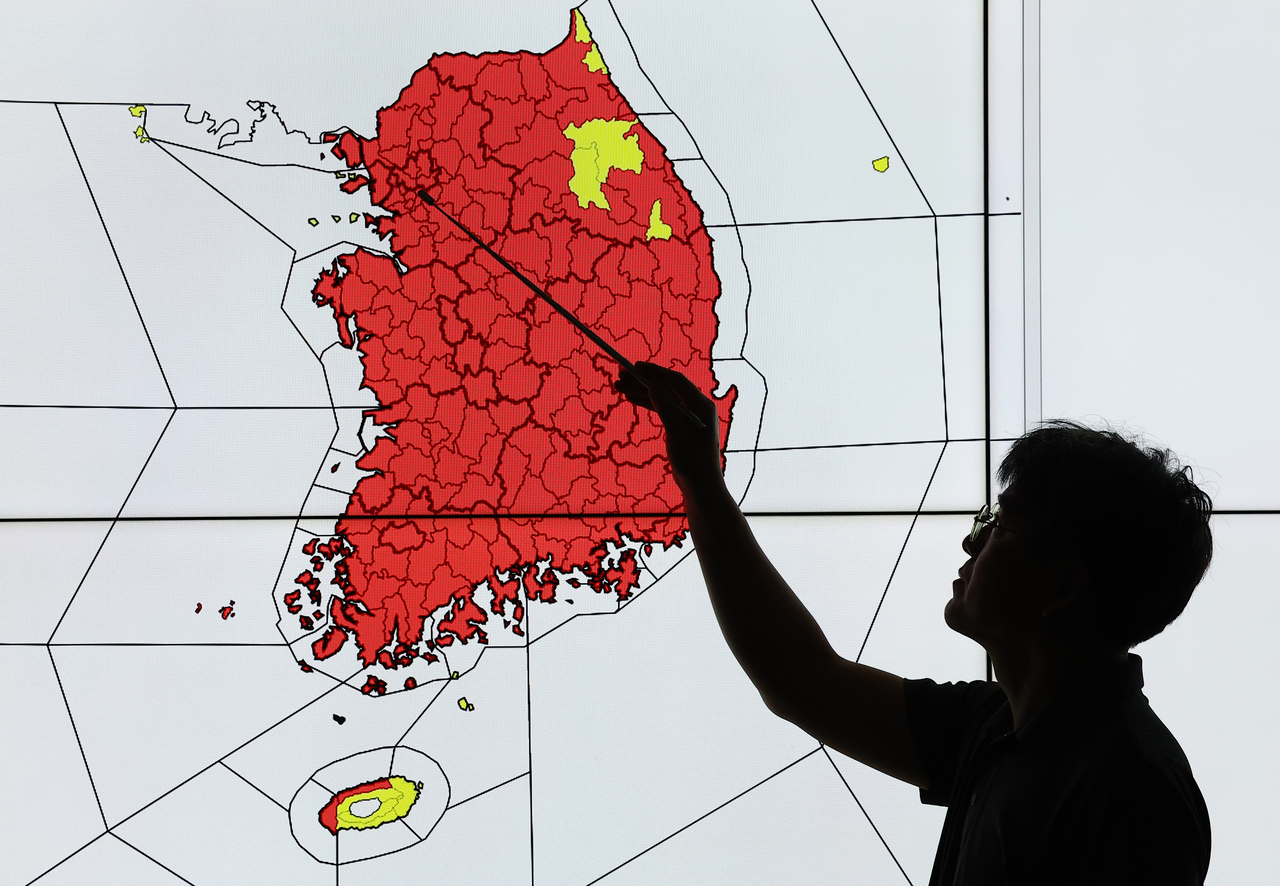
As of 5 p.m., Wednesday, heat wave warnings were issued in most parts of the country, as average apparent temperatures ranged from 32 C to 38 C. Such warnings are issued here when the maximum temperature is expected to surpass 35 C for two or more consecutive days.
A heat wave watch — issued when apparent temperatures are expected to reach above 33 C for two or more consecutive days — has also been issued in Taebaek, Gangwon Province, since Tuesday. This is considered quite unusual, as according to the weather records from the KMA, Taebaek does not often experience heat waves, as the city is at an elevation of nearly 900 meters.
Including Taebaek, 181 of 183 regions where weather records are kept — or 98.9 percent of the country — are now under a heat wave watch or warning. Of those regions, 161 are under heat wave warnings, while the remaining 20 regions are under a heat wave watch. The only locations currently unaffected by the heat waves are mountainous areas in Jeju Island and the Chuja Islands, a group of 42 islands in the Jeju Strait.

Data for this summer so far shows that it is already shaping up to be one of the hottest summers on record.
Between June 1 and Tuesday, the KMA stated that average daily temperatures over the 59 days reached 24.9 C nationwide — the highest average temperature seen over the same period since 1973.
The average daily high during the same period hit 30 C, also the highest on record.
Korea also saw an average of 15 heat wave days since June 1, the third-highest figure ever recorded since 1973.
Current weather conditions have prompted comparisons with the three years frequently cited as Korea’s hottest years on record — 1994, 2018 and 2024. Each of those summers saw the simultaneous expansion of the Tibetan high-pressure system and the North Pacific high-pressure system, similar to the weather conditions being observed this year.
In 1994, 29.6 heat wave days were recorded as well as 16.8 tropical nights, influenced by the El Nino event that kept sea surface temperatures high, influencing the development of the North Pacific high-pressure system. Widely remembered as one of the most intense summers in Korea’s modern history, 2018 surpassed such summer records, recording a total of 31 heat wave days.
In 2024, a record was set for the highest number of tropical nights (24.5) with a total of 30.1 heat wave days. Seoul also saw its first-ever September heat wave warning last year, with much of the country enduring tropical nights over its midautumn harvest festival, or Chuseok.

While this year’s summer may not differ dramatically compared to past record-breaking years in terms of its intensity or atmospheric drivers, experts note an important distinction — that it “began earlier than usual.”
“Climate change can be pointed to as the main factor behind the ongoing extreme heat. Whenever the North Pacific high-pressure system and the Tibetan high-pressure system expand over the Korean Peninsula, the sun continues to heat the ground and trap the heat,” said professor Kim Baek-min of Pukyong National University’s Division of Earth and Environmental System Sciences in a radio interview with SBS.
“Conditions that allow these two systems to linger over the peninsula are becoming more frequent, so extreme heat isn’t a temporary phenomenon. It’s something we’re likely to keep seeing.”
The heat shows no signs of easing. According to the KMA, average temperatures in August are expected to remain above average nationwide, with the probability of seeing above-average temperatures throughout the month estimated at 60 percent.
Hot, intense weather is expected to persist for the next few days, with high temperatures expected to reach up to 36 C to 37 C nationwide until Friday. Heat wave advisories, followed by tropical nights, are also expected to persist.
lee.jungjoo@heraldcorp.com


